


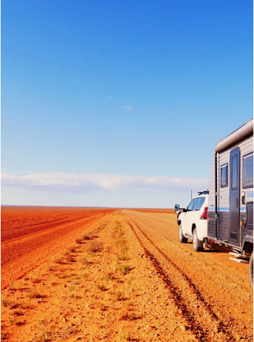


Goog's Track is a 4WD track located in South Australia, running from Ceduna to Kingoonya, with a distance of approximately 500km. It has been compared to a miniature cross between the Canning Stock Route and the Simpson Desert, with diverse landscapes including sand dunes, rocky outcrops, salt lakes, and mulga scrub. However, unlike those remote locations, Goog's Track benefits from being close to a major town and is suitable for a two or three-day adventure.
The track was named after Goog (real name Reginald Edward Sprigg), a South Australian explorer and geologist who discovered significant mineral deposits in the area. Goog believed that road access from Ceduna to the railway junction at Tarcoola would be of considerable value to the district and was so strong in his conviction that he set out to build the road himself. Others became influenced by his enthusiasm and offered support along the way, but Goog was the driving force and his family his main helpers.
Although Goog's original vision was for a modern road, he may have been disappointed with the lack of support by the government. However, Goog would be delighted with the use his road now gets as an adventure trail. Camping is allowed along the track, with designated camping areas and basic facilities available at certain points. It is recommended to have a high-clearance 4WD vehicle, proper equipment, and to travel with others when attempting the track. However, the track is not recommended for novice 4WD drivers, and caution should always be exercised due to the remote location and potential hazards.
This Westprint map covers the extent of Googs Track from Ceduna - Tarcoola - Kingoonya - Wirrulla.
All Westprint maps contain notes on history, explorers, points of interest, surrounding flora and fauna and contain various photos of landmarks. The maps are very clear to read and have road and track distances, rest areas, specific 4WD, caravan and camping information, heritage and tourist information, national parks and reserves, Lat/Long grid and GPS co-ordinates.


In Stock

Mastercard

Visa
Afterpay

Paypal

Applepay
Description
Specifications
5th Edition 2025
Scale 1:1,000,000
Field Checked with GPS
Detail roads and tracks
National Parks and Reserves
Specific 4WD, caravan and camping information
Cultural, historical and tourist information
Informative text about the region
Printed on a waterproof and tearproof polymer
Have a Question About This Item
Thank you, your enquiry has been received and our team will be in touch!
Product Terms & Conditions
